Note: this page, Databases and data access APIs lists various ways of reading OSM data into databases. They list these among choices:
I think all of these are going to get used.
more installation notes:
-f Postgres, so make sure GDAL compilation has Posggresql: yes in itlibosmium is use extensivelyMost of the steps are from:
1) set up terminal session:
at the beginning of each terminal session, start a python venv:
    cd ~/openmaptiles/vmpython
    source bin/activate
    export LD_LIBRARY_PATH=/home/wendell/usr/local/lib64:/home/wendell/usr/local/lib
2) ensure our own PosgGreSQL is running
ps aux
if not, then (not necessarily in a venv session):
    cd ~/openmaptiles
    ./start_stop_pg.sh start
3) psql to our d.b.:
use our psql, not system one:
    unset PGPORT
    unset PGUSER
    unset PGDATABASE
    unset PGPASSWORD
    unset PGHOST
    psql --port 55432 openmaptiles
4) if re-compilation needed
use these for new packages:
    ./configure --prefix=/home/wendell/usr/local
    cmake -DCMAKE_INSTALL_PREFIX=/home/wendell/usr/local/ ..
    PKG_CONFIG_PATH=/home/wendell/usr/local/lib/pkgconfig:/home/wendell/usr/local/lib64/pkgconfig
text notes describing these steps are on my work laptop in:
~/gis/openmaptiles/opalstack/notes_opalstack.txt~/gis/openmaptiles/opalstack/notes_omt_libraries.txt~/gis/openmaptiles/opalstack/notes_postgis.txtmanually performed, script not used
1) ====> : Filtering border from PBF lanet-latest.osm.pbf to osmborder_lines.pbf
run a cpp program from osmborder (from git?)
from osmborder's readme.md:
OSMBorder extracts the admin boundary data from an OSM planet file and assembles all the pieces into linestrings for use in map renderers etc.
osmborder_filter -o /home/wendell/openmaptiles/wdb-map-gen/data/osmborder_lines.pbf /home/wendell/openmaptiles/wdb-map-gen/data/planet-latest.osm.pbf
then create a .csv file from that .pbf file
2) ====> : Creating CSV osmborder_lines.csv from osmborder_lines.pbf
osmborder -o /home/wendell/openmaptiles/wdb-map-gen/data/osmborder_lines.csv /home/wendell/openmaptiles/wdb-map-gen/data/osmborder_lines.pbf
seems to have succeeded:
    du -sh data/*.csv
    3.4G    data/osmborder_lines.csv
possibly already done by previous run of the load_water step
cd ~/openmaptiles/wdb-map-gen/
note: opalstack is slow, it may be faster to d/l to rserver, then scp from there to opalstack
download 723 MB file from osmdata.openstreetmap.de
    wget https://osmdata.openstreetmap.de/download/water-polygons-split-4326.zip -P data
    unzip -o data/water-polygons-split-4326.zip -d data
this produces a directory of one hugh shapefile:
    > file water-polygons-split-4326/*
    water-polygons-split-4326/README.txt:         ASCII text
    water-polygons-split-4326/water_polygons.cpg: ASCII text
    water-polygons-split-4326/water_polygons.dbf: DBase 3 data file (53271 records)
    water-polygons-split-4326/water_polygons.prj: ASCII text, with no line terminators
    water-polygons-split-4326/water_polygons.shp: ESRI Shapefile version 1000 length 542279024 type Polygon
    water-polygons-split-4326/water_polygons.shx: ESRI Shapefile version 1000 length 213134 type Polygon
load shapefiles into postgis
using ogr2ogr (compiled with 'Postgresql:yes'), load those shapefiles into postgis:
    ogr2ogr -progress -f Postgresql \
         -s_srs EPSG:3857 -t_srs EPSG:3857 \
         -lco OVERWRITE=YES -lco GEOMETRY_NAME=geometry -overwrite \
         -nln osm_ocean_polygon -nlt geometry \
         --config PG_USE_COPY YES \
         'PG:dbname=openmaptiles user=tiles host=localhost password=xxxx port=55432' \
         data/water-polygons-split-4326/water_polygons.shp

    0...10...20...30...40...50...60...70...80...90...100 - done.
which creates this PostGIS table:
    > psql -p 55432 openmaptiles

    openmaptiles=# \d osm_ocean_polygon
                       Table "public.osm_ocean_polygon"
      Column  |          Type           | Collation | Nullable | ...
    ----------+-------------------------+-----------+----------+-
     ogc_fid  | integer                 |           | not null | ...
     x        | numeric(9,0)            |           |          |
     y        | numeric(9,0)            |           |          |
     geometry | geometry(Geometry,3857) |           |          |
    Indexes:
        "osm_ocean_polygon_pkey" PRIMARY KEY, btree (ogc_fid)
        "osm_ocean_polygon_geometry_geom_idx" gist (geometry)

    openmaptiles=# select count(*) from osm_ocean_polygon;
     53271
things around eastern seaboard:
    openmaptiles=# select ogc_fid, x, y
                   from osm_ocean_polygon
                   where x < -76 and x > -80 and y > 36 and y < 38;
     ogc_fid |  x  | y
    ---------+-----+----
        7251 | -78 | 37
        7252 | -78 | 37
        7253 | -78 | 37
        7254 | -78 | 37
        7255 | -78 | 37
        8865 | -77 | 37
        ...
picking one at random:
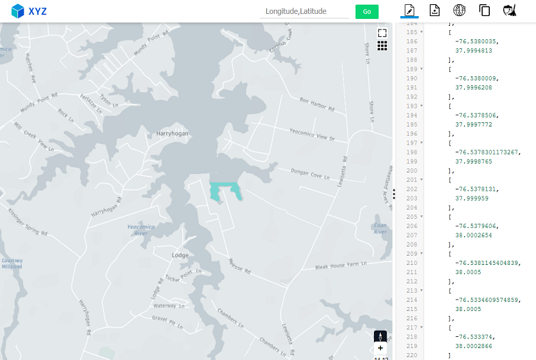
    openmaptiles=# select ST_AsGeoJson(geometry) from osm_ocean_polygon where ogc_fid = 8867;
     {"type":"Polygon","coordinates":[[[-76.533374,38.0002866],[...
which is a small portion of the Chesapeake Bay.
Note: geom is 3857, don't know if that is going to matter later.
seems good so far.
import data from osm world file (we're using the dallas-area crop until it works)
apparently this impostm import does this:
tools/imposm3/bin/imposm import \
     -connection postgis://tiles:xxxx@localhost:55432/openmaptiles \
     -mapping /home/wendell/openmaptiles/wdb-map-gen/config/lake_centerlines.yaml \
     -overwritecache \
     -cachedir /home/wendell/openmaptiles/wdb-map-gen/data/imposm3_cache \
     -read /home/wendell/openmaptiles/wdb-map-gen/data/dallas.osm.pbf \
     -dbschema-import=public \
     -write

[2021-10-02T15:28:57Z] 0:00:00 [info] removing existing cache /home/wendell/openmaptiles/wdb-map-gen/data/imposm3_cache
[2021-10-02T15:28:57Z] 0:00:00 [step] Starting: Imposm
[2021-10-02T15:28:57Z] 0:00:00 [step] Starting: Reading OSM data
[2021-10-02T15:28:57Z] 0:00:00 [info] reading /home/wendell/openmaptiles/wdb-map-gen/data/dallas.osm.pbf with data till 2021-09-05 23:59:59 +0000 UTC
[2021-10-02T15:29:14Z] 0:00:16 [progress]    16s C:       0/s (23036916) N:       0/s (4) W:       0/s (3371824) R:      0/s (5366)
[2021-10-02T15:29:14Z] 0:00:17 [step] Finished: Reading OSM data in 16.884572337s
[2021-10-02T15:29:14Z] 0:00:17 [step] Starting: Importing OSM data
[2021-10-02T15:29:14Z] 0:00:17 [step] Starting: Writing OSM data
[2021-10-02T15:29:25Z] 0:00:27 [step] Finished: Writing OSM data in 10.744546117s
[2021-10-02T15:29:25Z] 0:00:27 [step] Starting: Creating generalized tables
[2021-10-02T15:29:25Z] 0:00:27 [progress]    10s C:       0/s ( 0.0%) N:       0/s (100.0%) W:       0/s (100.0%) R:      0/s (100.0%)
[2021-10-02T15:29:25Z] 0:00:27 [step] Finished: Creating generalized tables in 322.01µs
[2021-10-02T15:29:25Z] 0:00:27 [step] Starting: Creating geometry indices
[2021-10-02T15:29:25Z] 0:00:27 [step] Starting: Creating geometry index on osm_lake_polygon
[2021-10-02T15:29:25Z] 0:00:27 [step] Finished: Creating geometry index on osm_lake_polygon in 2.375729ms
[2021-10-02T15:29:25Z] 0:00:27 [step] Finished: Creating geometry indices in 2.624851ms
[2021-10-02T15:29:25Z] 0:00:27 [step] Finished: Importing OSM data in 10.747612098s
[2021-10-02T15:29:25Z] 0:00:27 [step] Finished: Imposm in 27.632324887s
the mapping yaml file is:
    > cat config/lake_centerlines.yaml
    tables:
      lake_polygon:
        fields:
        - name: osm_id
          type: id
        - name: geometry
          type: validated_geometry
        - name: area
          type: area
        - name: name
          key: name
          type: string
        mapping:
          water:
          - lake
        type: polygon
and the PostGIS table is:
    openmaptiles=# \d osm_lake_polygon
               Table "public.osm_lake_polygon"
      Column  |          Type           | Collation | Nullable |
    ----------+-------------------------+-----------+----------+
     id       | integer                 |           | not null |
     osm_id   | bigint                  |           | not null |
     area     | real                    |           |          |
     name     | character varying       |           |          |
     geometry | geometry(Geometry,3857) |           |          |
    Indexes:
        "osm_lake_polygon_pkey" PRIMARY KEY, btree (osm_id, id)
        "osm_lake_polygon_geom" gist (geometry)
and:
    openmaptiles=# select id, osm_id, area, name from osm_lake_polygon limit 22;
     id |  osm_id   |     area      |                  name
    ----+-----------+---------------+----------------------------------------
      1 |   -253990 |    6.6655e+07 | Lake Bridgeport
      2 |  -2136481 |      794332.9 | Echo Lake
      3 |  -2136483 | 2.1545932e+06 | Caddo Creek Lake
      4 |  -2142482 |      842893.1 | Old Lake
      5 |  -2136480 | 1.4044872e+06 | Rhine Lake
      6 |  -2142480 | 1.1932928e+06 | Terra Verda Lake
      7 |  -2142500 | 3.6061308e+06 | Trinidad Lake
      8 |  -2142485 |  3.391756e+06 | Koon Kreek Lake
      9 |  -2142285 |  2.610082e+06 | Soil Conservation Service Site 42 Lake
     10 |   -952396 | 1.1748455e+08 | Lake Ray Hubbard
     11 |  -2463236 |  6.147459e+06 | Lake Crook
     12 |  -2142396 | 1.8643422e+07 | Bardwell Lake
     13 |  -2578321 | 1.1506677e+08 | Lavon Lake
     14 |  -2136180 | 8.3540145e+06 | Lake Athens
     15 |  -2140470 |  2.097937e+07 | Benbrook Lake
     16 |  -4049995 |     28289.719 | Heritage Lake
     17 |   -937920 | 1.0371684e+08 | Jim Chapman Lake
     18 |  -6521733 |     221178.89 |
     19 |  -6904538 |      69343.21 | Wilemon Lake
     20 |  -8905912 | 1.6584081e+06 | Lake Viridian
and one of them looks like:
    openmaptiles=# select ST_AsGeoJson(geometry) from osm_lake_polygon where name='Lake Bridgeport';
     {"type":"Polygon","coordinates":[[[-10904350.3505353,3928761.52079316],
                                       [-10904344.6214904,3928779.6629242],
                                       [-10904332.1930088,3928788.26538367],
                                       [-10904315.9576048,3928793.04081139],
                                       [-10904296.839017,3928799.73533953],
HELP!!! What coordinates are these???
not sure where this geojson file came from...
not sure what we're doing here...
    ogr2ogr -progress -f Postgresql \
          -t_srs EPSG:3857  \
          'PG:dbname=openmaptiles user=tiles host=localhost password=xxxx port=55432' \
          -lco OVERWRITE=YES -overwrite \
          -nln lake_centerline data/lake_centerline.geojson

    0...10...20...30...40...50...60...70...80...90...100 - done.
which created this table:
    openmaptiles=# \d lake_centerline
           Table "public.lake_centerline"
        Column    |           Type            | Collation | Nullable |
    --------------+---------------------------+-----------+----------+
     ogc_fid      | integer                   |           | not null |
     osm_id       | double precision          |           |          |
     wkb_geometry | geometry(LineString,3857) |           |          |
    Indexes:
        "lake_centerline_pkey" PRIMARY KEY, btree (ogc_fid)
        "lake_centerline_wkb_geometry_geom_idx" gist (wkb_geometry)

    openmaptiles=# select ogc_fid, osm_id from lake_centerline limit 22;
     ogc_fid |  osm_id
    ---------+-----------
           1 |  -1520541
           2 |  -1082659
           3 |  -7213401
           4 |   -338774
          34 |  -1603199
       26023 | 366984344
           5 |  -1125603
           6 |  -2194833
    ...
AGAIN, unknown coordinates:
    openmaptiles=# select ST_AsGeoJson(wkb_geometry) from lake_centerline where ogc_fid = 5391;
     {"type":"LineString","coordinates":[[16321515.0629178,10161155.438388],
                                         [16321494.3388573,10161161.5248103],...
====> : Importing shape files into Postgresql
0...10...20...30...40...50...60...70...80...90...100 - done.
0...10...20...30...40...50...60...70...80...90...100 - done.
<lots of these>
====> : Start importing /home/wendell/openmaptiles/wdb-map-gen/data/natural_earth_vector.sqlite into Postgresql
(re-compiled GDAL yet again, and it finally worked):
    ogr2ogr -progress -f Postgresql \
    -s_srs EPSG:4326 -t_srs EPSG:3857 \
    -clipsrc -180.1 -85.0511 180.1 85.0511
    'PG:dbname=openmaptiles user=tiles host=.. password=.. port=55432' \
    -lco GEOMETRY_NAME=geometry -lco OVERWRITE=YES -lco DIM=2  \
    -nlt GEOMETRY -overwrite /h/w/o/w/data/natural_earth_vector.sqlite

0...10...20...30...40...50...60...70...80...90...100 - done.
Holy cow! 337 tables (and 337 sequences created):
                      List of relations
 Schema |             Name                               |   Type   |  Owner
--------+------------------------------------------------+----------+---------
 public | ne_10m_admin_0_antarctic_claim_limit_lines     | table    | tiles
 public | ne_10m_admin_0_antarctic_claims                | table    | tiles
 ...
 public | ne_10m_wgs84_bounding_box                      | table    | tiles
 public | ne_110m_admin_0_boundary_lines_land            | table    | tiles
 ...
 public | ne_50m_admin_0_tiny_countries                  | table    | tiles
 public | ne_50m_admin_0_tiny_countries_scale_rank       | table    | tiles
 ...
 public | ne_50m_airports                                | table    | tiles
 ..
 public | ne_50m_urban_areas                             | table    | tiles
 public | ne_50m_wgs84_bounding_box                      | table    | tiles
and one of them looks like:
openmaptiles=# \d ne_50m_airports
                                         Table "public.ne_50m_airports"
   Column   |          Type           | Collation | Nullable |                     Default
------------+-------------------------+-----------+----------+--------------------------------------------------
 ogc_fid    | integer                 |           | not null | nextval('ne_50m_airports_ogc_fid_seq'::regclass)
 scalerank  | integer                 |           |          |
 featurecla | character varying       |           |          |
 type       | character varying       |           |          |
 name       | character varying       |           |          |
 abbrev     | character varying       |           |          |
 location   | character varying       |           |          |
 gps_code   | character varying       |           |          |
 iata_code  | character varying       |           |          |
 wikipedia  | character varying       |           |          |
 natlscale  | double precision        |           |          |
 comments   | character varying       |           |          |
 wikidataid | character varying       |           |          |
 name_en    | character varying       |           |          |
 wdid_score | integer                 |           |          |
 ne_id      | bigint                  |           |          |
 geometry   | geometry(Geometry,3857) |           |          |
Indexes:
    "ne_50m_airports_pkey" PRIMARY KEY, btree (ogc_fid)
    "ne_50m_airports_geometry_geom_idx" gist (geometry)
and:
openmaptiles=# select type, name, abbrev, location, iata_code from ne_50m_airports where name like '%Dallas%';
 type  |          name          | abbrev | location | iata_code
-------+------------------------+--------+----------+-----------
 major | Dallas-Ft. Worth Int'l | DFW    | parking  | DFW
 major | Dallas-Ft. Worth Int'l | DFW    | parking  | DFW
 major | Dallas-Ft. Worth Int'l | DFW    | parking  | DFW
 major | Dallas-Ft. Worth Int'l | DFW    | parking  | DFW
 major | Dallas-Ft. Worth Int'l | DFW    | parking  | DFW
 major | Dallas-Ft. Worth Int'l | DFW    | parking  | DFW
(6 rows)

openmaptiles=# select type, name, abbrev, location, iata_code from ne_50m_airports where name like '%Chicago%';
 type  |         name         | abbrev | location | iata_code
-------+----------------------+--------+----------+-----------
 major | Chicago O'Hare Int'l | ORD    | terminal | ORD
 major | Chicago O'Hare Int'l | ORD    | terminal | ORD
 major | Chicago O'Hare Int'l | ORD    | terminal | ORD
 major | Chicago O'Hare Int'l | ORD    | terminal | ORD
 major | Chicago O'Hare Int'l | ORD    | terminal | ORD
 major | Chicago O'Hare Int'l | ORD    | terminal | ORD
and they're still in some projection using meters:
openmaptiles=# select ST_AsGeoJson(geometry) from ne_50m_airports where  name like '%Dallas%' limit 1;
                            st_asgeojson
---------------------------------------------------------------------
 {"type":"Point","coordinates":[-10802484.6943607,3882058.10739509]}
CAUTION: the download script uses asyncio.run, which is a Python3.7 addition
I think it has to be manually downloaded.
INOP: + download-osm planet -o data/nc.osm.pbf
1) get a bouning box of NC
http://bboxfinder.com/#34.633208,-82.265625,36.703660,-76.464844
2) crop the (gigantic) planet.osm.pbf to something smaller...
osmconvert:
-b=<x1>,<y1>,<x2>,<y2>

    If you want to limit the geographical region, you can define a bounding box.
    To do this, enter the __southwestern and the northeastern corners__ of that area.
which makes it:
osmconvert planet-latest.osm.pbf -b=-82.265625,34.633208,-76.464844,36.703660 -o=nc.osm.pbf
    tools/imposm3/bin/imposm import -config /home/wendell/openmaptiles/wdb-map-gen/config/generated/imposm.json \
    -overwritecache -read data/nc4.osm.pbf -deployproduction -write -diff
which says (I have no idea what diff mode is):
Importing in diff mode
+ tools/imposm3/bin/imposm import -config /home/wendell/openmaptiles/wdb-map-gen/config/generated/imposm.json -overwritecache -read data/nc4.osm.pbf -deployproduction -write -diff
[2021-10-03T19:37:34Z] 0:00:00 [info] removing existing cache /home/wendell/openmaptiles/wdb-map-gen/data/imposm3_cache
[2021-10-03T19:37:34Z] 0:00:00 [step] Starting: Imposm
[2021-10-03T19:37:34Z] 0:00:00 [step] Starting: Reading OSM data
[2021-10-03T19:37:34Z] 0:00:00 [info] reading data/nc4.osm.pbf with data till 2021-09-05 23:59:59 +0000 UTC
[2021-10-03T19:37:58Z] 0:00:24 [progress]    24s C:       0/s (38065496) N:       0/s (444825) W:       0/s (3673811) R:      0/s (11161)
[2021-10-03T19:37:58Z] 0:00:24 [step] Finished: Reading OSM data in 24.295867171s
[2021-10-03T19:37:58Z] 0:00:24 [step] Starting: Importing OSM data
[2021-10-03T19:37:58Z] 0:00:24 [step] Starting: Writing OSM data
[2021-10-03T19:38:58Z] 0:01:24 [progress]   1m0s C:       0/s ( 0.0%) N:       0/s ( 0.0%) W:   52100/s (72.1%) R:    190/s (100.0%)
[2021-10-03T19:39:16Z] 0:01:41 [progress]  1m17s C:       0/s ( 0.0%) N:       0/s (100.0%) W:   72300/s (100.0%) R:    190/s (100.0%)
[2021-10-03T19:39:16Z] 0:01:42 [step] Finished: Writing OSM data in 1m17.302576866s
[2021-10-03T19:39:16Z] 0:01:42 [step] Starting: Creating generalized tables
[2021-10-03T19:39:16Z] 0:01:42 [step] Starting: Generalizing osm_aerialway_linestring into osm_aerialway_linestring_gen_z12
[2021-10-03T19:39:16Z] 0:01:42 [step] Starting: Generalizing osm_aeroway_linestring into osm_aeroway_linestring_gen_z12
[2021-10-03T19:39:16Z] 0:01:42 [step] Starting: Generalizing osm_railway_linestring into osm_railway_linestring_gen_z12
[2021-10-03T19:39:16Z] 0:01:42 [step] Starting: Generalizing osm_border_disp_relation into osm_border_disp_linestring
[2021-10-03T19:39:16Z] 0:01:42 [step] Starting: Generalizing osm_park_polygon into osm_park_polygon_gen_z13
...
[2021-10-03T19:39:21Z] 0:01:47 [step] Starting: Creating geometry indices
[2021-10-03T19:39:21Z] 0:01:47 [step] Starting: Creating geometry index on osm_border_disp_relation
[2021-10-03T19:39:21Z] 0:01:47 [step] Starting: Creating geometry index on osm_peak_point
[2021-10-03T19:39:21Z] 0:01:47 [step] Starting: Creating geometry index on osm_island_point
[2021-10-03T19:39:21Z] 0:01:47 [step] Starting: Creating OSM id index on osm_railway_linestring_gen_z11
[2021-10-03T19:39:21Z] 0:01:47 [step] Starting: Creating OSM id index on osm_shipway_linestring_gen_z12
[2021-10-03T19:39:21Z] 0:01:47 [step] Starting: Creating geometry index on osm_building_polygon
[2021-10-03T19:39:21Z] 0:01:47 [step] Starting: Creating OSM id index on osm_border_disp_linestring_gen_z12
[2021-10-03T19:39:21Z] 0:01:47 [step] Starting: Creating geometry index on osm_landuse_polygon
[2021-10-03T19:39:21Z] 0:01:47 [step] Starting: Creating geometry index on osm_country_point
[2021-10-03T19:39:21Z] 0:01:47 [step] Starting: Creating geometry index on osm_shipway_linestring
...
[2021-10-03T19:39:40Z] 0:02:06 [step] Starting: Rotating tables
[2021-10-03T19:39:40Z] 0:02:06 [info] Rotating osm_route_member from import -> public -> backup
[2021-10-03T19:39:40Z] 0:02:06 [info] Rotating osm_island_polygon from import -> public -> backup
[2021-10-03T19:39:40Z] 0:02:06 [info] Rotating osm_aerodrome_label_point from import -> public -> backup
[2021-10-03T19:39:40Z] 0:02:06 [info] Rotating osm_city_point from import -> public -> backup
...
[2021-10-03T19:39:40Z] 0:02:06 [step] Finished: Rotating tables in 173.10067ms
[2021-10-03T19:39:40Z] 0:02:06 [step] Finished: Imposm in 2m6.507305141s
+ set +x
====> : End importing Planet OpenStreetMap data: data/nc4.osm.pbf -> imposm3[./config/mapping.yaml] -> PostgreSQL
ok, not all that long (for N.C. alone), let's take a look:
openmaptiles=# \dt *railway*
                    List of relations
 Schema |              Name              | Type  | Owner
--------+--------------------------------+-------+-------
 public | osm_railway_linestring         | table | tiles
 public | osm_railway_linestring_gen_z10 | table | tiles
 public | osm_railway_linestring_gen_z11 | table | tiles
 public | osm_railway_linestring_gen_z12 | table | tiles
 public | osm_railway_linestring_gen_z8  | table | tiles
 public | osm_railway_linestring_gen_z9  | table | tiles
(6 rows)
and:
openmaptiles=# \d osm_railway_linestring;
              Table "public.osm_railway_linestring"
   Column   |           Type            | Collation | Nullable |    Default
------------+---------------------------+-----------+----------+----
 id         | integer                   |           | not null | nextval(...
 osm_id     | bigint                    |           | not null |
 railway    | character varying         |           |          |
 ref        | character varying         |           |          |
 network    | character varying         |           |          |
 z_order    | integer                   |           |          |
 layer      | integer                   |           |          |
 level      | integer                   |           |          |
 indoor     | boolean                   |           |          |
 name       | character varying         |           |          |
 name_en    | character varying         |           |          |
 name_de    | character varying         |           |          |
 tags       | hstore                    |           |          |
 short_name | character varying         |           |          |
 is_tunnel  | boolean                   |           |          |
 is_bridge  | boolean                   |           |          |
 is_ramp    | boolean                   |           |          |
 is_ford    | boolean                   |           |          |
 is_oneway  | smallint                  |           |          |
 is_area    | boolean                   |           |          |
 service    | character varying         |           |          |
 usage      | character varying         |           |          |
 geometry   | geometry(LineString,3857) |           |          |
Indexes:
    "osm_railway_linestring_pkey" PRIMARY KEY, btree (osm_id, id)
    "osm_railway_linestring_geom" gist (geometry)
and:
openmaptiles=# select railway, network, name, name_en, short_name, service, usage from osm_railway_linestring where name != '' limit 55;
  railway  |                    name                     | service |   usage
-----------+---------------------------------------------+---------+------------
 rail      | Pulaski District                            |         | main
 rail      | Lancaster and Chester                       |         | branch
 rail      | Edgemoor and Manetta Railway                | spur    |
 rail      | Lancaster and Chester Railroad              |         | branch
 rail      | Lancaster and Chester                       |         | branch
 rail      | Wallace Siding                              | siding  |
 rail      | Monroe Subdivision                          |         | main
...
 rail      | High Point, Thomasville and Denton Railroad |         |
 rail      | High Point, Thomasville and Denton Railroad |         |
 rail      | Winston-Salem District                      |         | main
 rail      | Winston-Salem District                      |         | main
 rail      | Duke Branch                                 | spur    |
 rail      | Charlotte Subdivision                       |         | main
 rail      | Aberdeen and Rockfish Railroad              |         | branch
 ...
 rail      | Winston-Salem Southbound Railway            |         | branch
 rail      | North Carolina and Virginia Railroad        |         | branch
 rail      | North Carolina and Virginia Railroad        |         | branch
 rail      | North Carolina and Virginia Railroad        |         | branch
but still, units are meters:
openmaptiles=# select ST_AsGeoJson(geometry) from osm_railway_linestring where name like '%Denton%';
 {"type":"LineString","coordinates":[[-8913409.74216988,4284236.53777683],...
this seemed useful:
> vim ./osm_pkgs/openmaptiles-tools/build/scripts-3.6/import-wikidata

if __name__ == '__main__':
    #wt: asyncio.run(main(docopt(__doc__, version=openmaptiles.__version__)))
    loop = asyncio.get_event_loop()
    loop.run_until_complete(main(docopt(__doc__, version=openmaptiles.__version__)))

(vmpython) wendell@opal4:~/openmaptiles/osm_pkgs/openmaptiles-tools
> python3 setup.py build

running build
running build_py
running build_scripts

(vmpython) wendell@opal4:~/openmaptiles/osm_pkgs/openmaptiles-tools
> python3 setup.py install

running install
after edits for async.run as above:
./load_wikidata.sh
which seemed to work:
Found 13 tables with the 'tags' hstore fields
  * osm_aerodrome_label_point
  * osm_city_point
  * osm_continent_point
  * osm_country_point
  * osm_island_point
  * osm_island_polygon
  * osm_marine_point
  * osm_peak_point
  * osm_poi_point
  * osm_poi_polygon
  * osm_state_point
  * osm_water_polygon
  * osm_waterway_linestring
Cache file /home/wendell/openmaptiles/wdb-map-gen/data/cache/wikidata-cache.json does not exist, will create
Searching for Wikidata IDs in 13 tables...
Found 1,674 Wikidata IDs to load.
Dropping and Re-creating wd_names table...
  NOTICE: table "wd_names" does not exist, skipping @ None
Query Wikidata Query Service for 1,674 IDs...
Inserted 1,669 Wikidata IDs from WDQS into wd_names table
Resolving 5 possible Wikidata redirects...
5 out of 5 Wikidata ID redirects were found
Querying Wikidata for 5 redirect IDs...
Inserted 5 Wikidata IDs from WDQS into wd_names table
Saving 1,674 items to cache /home/wendell/openmaptiles/wdb-map-gen/data/cache/wikidata-cache.json
needed to edit for "-p $POSTGRES_PASS" in a couple of places
vim load_sql.sh
openmaptiles=# create database tiles; CREATE DATABASE openmaptiles=# \q (vmpython) wendell@opal4:~/openmaptiles
psql --port 55432 tilespsql (12.8) Type "help" for help.
tiles=# \d Did not find any relations. tiles=# create extension postgis; CREATE EXTENSION tiles=# create extension hstore; CREATE EXTENSION tiles=# grant all privileges on database tiles to tiles ; GRANT
ZZ then:
    ./load_sql.sh

Single-THREADED
-- Importing: /home/wendell/openmaptiles/wdb-map-gen/config/sql/CleanNumeric.sql --
CREATE FUNCTION
-- Importing: /home/wendell/openmaptiles/wdb-map-gen/config/sql/Z.sql --
CREATE FUNCTION
-- Importing: /home/wendell/openmaptiles/wdb-map-gen/config/sql/zzz_language.sql --
CREATE FUNCTION
CREATE FUNCTION

<lots of stuff>
then: CREATE FUNCTION psql:/home/wendell/openmaptiles/wdb-map-gen/data/sql/tileset.sql:7788: NOTICE: Finished layer aerodrome_label DO psql: error: FATAL: database "tiles" does not exist
SO, a database 'tiles' was created, BUT IT WAS NOT POPULATED!!!
and load_sql seemed to have completed
attempts to find out data format:
    > ogrinfo -al dallas.osm.pbf

    INFO: Open of `dallas.osm.pbf'
          using driver `OSM' successful.

    Layer name: points
    Geometry: Point
    Feature Count: -1
    Extent: (-98.300000, 32.000000) - (-95.520000, 33.850000)
    Layer SRS WKT:
    GEOGCRS["WGS 84",
        DATUM["World Geodetic System 1984",
            ELLIPSOID["WGS 84",6378137,298.257223563,
                LENGTHUNIT["metre",1]]],
        PRIMEM["Greenwich",0,
            ANGLEUNIT["degree",0.0174532925199433]],
        CS[ellipsoidal,2],
            AXIS["geodetic latitude (Lat)",north,
                ORDER[1],
                ANGLEUNIT["degree",0.0174532925199433]],
            AXIS["geodetic longitude (Lon)",east,
                ORDER[2],
                ANGLEUNIT["degree",0.0174532925199433]],
        ID["EPSG",4326]]
    Data axis to CRS axis mapping: 2,1
    osm_id: String (0.0)
    name: String (0.0)
    barrier: String (0.0)
    highway: String (0.0)
    ref: String (0.0)
    address: String (0.0)
    is_in: String (0.0)
    place: String (0.0)
    man_made: String (0.0)
    other_tags: String (0.0)
    OGRFeature(points):26451915
      osm_id (String) = 26451915
      highway (String) = motorway_junction
      other_tags (String) = "noref"=>"yes"
      POINT (-96.9963659 32.9878311)
and
    > ogrinfo  dallas.osm.pbf  lines | less

    INFO: Open of `dallas.osm.pbf'
          using driver `OSM' successful.

    Layer name: lines
    Geometry: Line String
    Feature Count: -1
    Extent: (-98.300000, 32.000000) - (-95.520000, 33.850000)
    Layer SRS WKT:
    GEOGCRS["WGS 84",
        DATUM["World Geodetic System 1984",
            ELLIPSOID["WGS 84",6378137,298.257223563,
                LENGTHUNIT["metre",1]]],
        PRIMEM["Greenwich",0,
            ANGLEUNIT["degree",0.0174532925199433]],
        CS[ellipsoidal,2],
            AXIS["geodetic latitude (Lat)",north,
                ORDER[1],
                ANGLEUNIT["degree",0.0174532925199433]],
            AXIS["geodetic longitude (Lon)",east,
                ORDER[2],
                ANGLEUNIT["degree",0.0174532925199433]],
        ID["EPSG",4326]]
    Data axis to CRS axis mapping: 2,1
    osm_id: String (0.0)
    name: String (0.0)
    highway: String (0.0)
    waterway: String (0.0)
    aerialway: String (0.0)
    barrier: String (0.0)
    man_made: String (0.0)
    z_order: Integer (0.0)
    other_tags: String (0.0)
    OGRFeature(lines):4342988
      osm_id (String) = 4342988
      name (String) = Sam Rayburn Tollway
      highway (String) = motorway
      z_order (Integer) = 9
      other_tags (String) = "lanes"=>"2","maxspeed"=>"70 mph","old_ref"=>"Toll 121",...
      LINESTRING (-96.9974646 32.9882702,-97.0004718 32.9894883,...

    OGRFeature(lines):4343083
      osm_id (String) = 4343083
      name (String) = Sam Rayburn Tollway
      highway (String) = motorway
      z_order (Integer) = 9
      other_tags (String) = "lanes"=>"3","maxspeed"=>"70 mph","old_ref"=>"Toll 121",...
      LINESTRING (-97.0060288 32.9905785,-97.0056765 32.990593,-97.0052949 32.9905893,...